Arkabutla Lake Info
About Arkabutla Lake
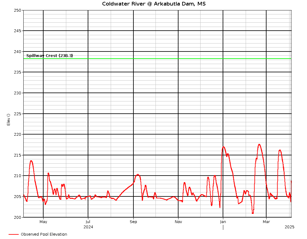
Delta Sailing Association is located on Arkabutla Lake, just south of Hernando, MS and about 30 miles south of Memphis, TN. The water level of the lake varies considerable during the year, since the primary mission of the Corps. of Engineers owned lake is flood control. Here is Lake level information from the Corps Of Engineers Vicksburg District.
Arkabutla Lake Current Water Level
Arkabutla Recreation
The recreation opportunities at Arkabutla Lake are very diverse and endless. Activities and areas established for recreation include: trails for hiking and biking, picnic areas, picnic shelters, ADA parking spaces at the boat ramps and recreation areas, an ADA accessible fishing pier, 3 swimming beaches including one that is ADA accessible, ADA accessible playgrounds, a variety of campgrounds, and we offer different activities for public involvement throughout the year. Recreation on the lake provides for some of the best fishing in the Southeast and some of the best sailing east of the Mississippi River. We also have over 30,000 acres of land open for public hunting. If you enjoy camping, swimming, hiking, boating, fishing, or hunting in a family friendly alcohol free environment, come see for yourself what Arkabutla Lake has to offer for your recreational needs.
History
After a series of disastrous floods during the mid-1800s and early 1900s, high priority was given to flood control projects. The worst flood in the history of the Lower Mississippi Valley occurred in 1927. The Great Flood spawned a comprehensive program for flood control along the Mississippi River and its tributaries and the U.S. Army Corps of Engineers became the planners, designers and builders of the flood control projects.
Engineers determined the headwaters of the Yazoo River contributed to or caused much of the flooding that occurred in Mississippi’s Delta region. In addition to the construction of levees along the Yazoo River, four flood control reservoirs were constructed in north Mississippi as part of the Yazoo Basin Headwater Project. Arkabutla Dam, the second of the dams to be built, was constructed on the Coldwater River.
The development of Arkabutla Dam even required the relocation of an entire town. In 1942, the U.S. Government moved the town of Coldwater and approximately 700 residents at a cost of $250,000 to its present location 1 mile south of the original site. Today there is a monument dedicated to the old town of Coldwater just west of the Coldwater exit off Interstate 55. There you can see a few remnants of the old town; however a majority of the site remains underwater year round.
When completed, the Yazoo Headwater Project will protect 1,209,000 acres of land against flooding and will partially protect another 303,000 acres. Benefits of the Headwater Project are reduced flooding around the cities of Greenwood, Yazoo City, Belzoni, and other smaller communities within the Yazoo River Basin and increased agricultural and industrial productivity because more land is available for these purposes. As a result, the region’s national and international markets for produce have greatly increased and families have benefited from the growing job market.